NC Gazetteer

Yancey County

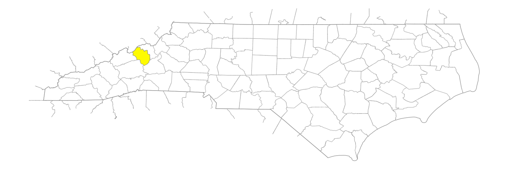
… was formed in 1833 from Burke and Buncombe Counties. Located in the W section of the state, it is bounded by the state of Tennessee and by Mitchell, McDowell, Buncombe, and Madison Counties. It was named for Bartlett Yancey (1785-1828), member of the General Assembly and Congress. Area: 311 sq. mi. County seat: Burnsville, with an elevation of 2,817 ft. Townships are Brush Creek, Burnsville, Cane River, Crabtree, Egypt, Green Mountain, Jacks Creek, Pensacola, Price Creek, Ramseytown, and South Toe. Produces corn, oats, poultry, dairy products, livestock, hogs, hosiery, carpets, lumber, hay, textiles, mica, feldspar, olivine, sand, and gravel.
areas

Flat Springs
Hoover Meadow

balds

Big Bald
Little Bald
Maple Camp Bald

branches

Allan Branch
Anglin Branch
Bailey Branch
Bailey Branch
Bailey Branch
Bailey Branch
Bear Rock Branch
Bee Branch
Bee Branch
Bee Stump Branch
Bill Allen Branch
Blue Rock Branch
Burgin Cove Branch
Burleson Branch
Byrds Branch
Cane Branch
Coxe Branch
Cynthia Branch
Deer Branch
Dover Branch
Dovers Branch
Dryspring Branch
East Branch
Edney Branch
English Branch
Falling Water Branch
Feds Branch
Fee Branch
Firescald Branch
Flattop Mountain Branch
Grassy Knob Branch
Hampton Branch
Hannah Branch
Hardscrabble Branch
Harris Branch
Hawk Branch
Hensley Branch
Howell Branch
Jackies Mill Branch
Jim Ray Branch
John Autrey Branch
Langford Branch
Laurel Branch
Laurel Branch
Laurel Branch
Lickskillet Branch
Little Hensley Branch
Mack Williams Branch
McIntosh Branch
McKinney Branch
Meredith Branch
Miller Branch
Mine Branch
Mitchell Branch
Moses Branch
Murphy Branch
Norris Branch
North Fork Hawk Branch
Parson Branch
Patterson Branch
Peterson Branch
Phipps Branch
Pine Ridge Branch
Pine Swamp Branch
Pit Branch
Plum Branch
Riddle Branch
Roland Branch
Sampson Branch
Seng Branch
Shateen Branch
Shepherd Branch
Sodom Branch
South Fork Hawk Branch
Star Branch
Still Branch
Sweet Branch
Sweetwater Branch
Tantrough Branch
Whistling Gap Branch
Whiteside Branch
Whitson Branch
Wolf Branch

communities

Adkins
Arbuckle
Bacchus
Bald Creek
Bald Mountain
Bee Log
Bent Creek
Boonford
Bowditch
Bowlens Creek
Busick
Cane Bottom
Cane River
Celo
Concord
Day Book
Elk Shoal
Elmer
Eskota
Green Mountain
Hamrick
Harvard
Hawk Branch
Higgins
Ivy Gap
Lewisburg
Lost Cove
Low Gap
Micaville
Murchison
Newdale
Paint Gap
Pensacola
Possumtrot
Prices Creek
Ramsaytown
Riverside
Sioux
Swiss
Toledo
Vixen
Whiteoak Flats
Wilhite
Windom

coves

Bailey Cove
Johnson Cove
Pounding Mill Cove

creeks

Ayles Creek
Baker Creek
Bald Creek
Bald Mountain Creek
Banks Creek
Beech Nursery Creek
Bent Creek
Big Crabtree Creek
Big Creek
Big Lost Cove Creek
Big Poplar Cree
Blankenship Creek
Blue Ridge Cove Creek
Blue Sea Creek
Bobs Creek
Bowlens Creek
Browns Creek
Cattail Creek
Charlie Creek
Clear Creek
Colbert Creek
Devils Creek
Doe Bag Creek
Elk Shoal Creek
Elk Wallow Creek
Fox Creek
Guilders Creek
Haney Creek
Hemphill Creek
Higgins Creek
Horton Creek
Indian Creek
Jacks Creek
Jim Creek
Left Prong Bent Creek
Left Prong Three Forks Creek
Little Brush Creek
Little Crabtree Creek
Little Creek
Little Lost Cove Creek
Little Mountain Creek
Little Spivey Creek
Little Whiteoak Creek
Locust Creek
Lottie Creek
Lower Creek
Maple Bald Creek
Maple Creek
Middle Creek
Mitchell Creek
Neals Creek
North Cox Creek
North Fork Cattail Creek
North Fork Rock Creek
Nubbinscuffle Creek
Ogle Creek
Patsy Creek
Phipps Creek
Pigpen Creek
Possumtrot Creek
Pounding Mill Creek
Price Creek
Right Prong Bent Creek
Right Prong Three Forks Creek
Roaring Spout Creek
Rock Creek
Rose Creek
Setrock Creek
Shingle Pile Creek
Shoal Creek
Shuford Creek
South Cox Creek
South Fork Cattail Creek
South Fork Rock Creek
South Fork Upper Creek
Spivey Creek
Sugar Camp Creek
Sugar Cove Creek
Three Forks Creek
Three Quarters Creek
Timber Creek
Toodies Creek
Upper Creek
Whiteoak Creek
Whiteoak Creek

forests

Pisgah National Forest

forks

Bloody Fork
Elk Fork
George Fork
Indian Fork
Middle Fork [Hawk Branch]
Middle Fork [Rock Creek]
Middle Fork [Upper Creek]
Mine Fork
Raven Fork
Roaring Fork
Roaring Fork
Simms Fork

gaps

Balsam Gap
Bear Gap
Beech Nursery Gap
Big Laurel Gap
Bill Wray Gap
Black Mountain Gap
Bowman Gap
Buck Creek Gap
Butler Gap
Campground Gap
Cane River Gap
Cooper Gap
Cox Creek Gap
Deep Gap
Deep Gap
Deep Gap
Devils Creek Gap
Dicks Gap
Flat Springs Gap
Flinty Gap
Green Mountain Gap
Harmiller Gap
Hazelnut Gap
Hickory Gap
Horse Trail Gap
Hurricane Gap
Ivy Gap
Ivy Gap
Jumpoff Gap
Low Gap
Low Gap
Mack Hill Gap
Maney Gap
McKinney Gap
Moore Gap
Ogle Gap
Oldfield Gap
Paint Gap
Paint Gap
Phipps Gap
Prather Gap
Rainbow Gap
Salt Rock Gap
Sampson Gap
Shate Gap
Shoal Creek Gap
Stepps Gap
Sugar Cove Gap
Swannanoa Gap
Tully Gap
Whistling Gap
Wolfpit Gap
Woodby Gap

hills

Bailey Hill
Commissary Hill
Ferguson Hill
Horton Hill
Potato Hill
Sid Hill

historical markers

Elisha Mitchell 1793-1857 historical marker
Lesley Riddle historical marker
Yancey Collegiate Institute historical marker

knobs

Anglin Knob
Bald Knob
Bald Knob
Bear Wallow Knob
Bear Wallow Knob
Big Butt Knob
Blackstock Knob
Blevine Knob
Blue Rock Knob
Bluerock Knob
Campground Knob
Celo Knob
Chestnut Knob
Chestnut Knob
Chrissawn Knob
Cox Knob
Elk Wallow Knob
Flat Springs Knob
Glass Rock Knob
Grassy Knob
Green Knob
Higgins Knob
High Knob
Houston Knob
Julius Knob
Little Butt Knob
Lookout Knob
Mill Knob
Mine Knob
Ogle Meadow Knob
Phillips Knob
Pinnacle Knob
Renfro Knob
Rocky Knob
Rocky Knob
Rocky Knob
Roland Knob
Simmons Knob
Slickrock Knob
Snake Knob
Stones Knob
Thunderstruck Knob
Thunderstruck Knob
Upper Haw Knob
White Hurricane Knob

mountain features

Arm, The
Black Brothers
Devils Den
High Peak
High Peak
Nettle Patch
Pigpen Bluff
Three Knobs

mountain ranges

Bald Mountains
Black Mountains
Walnut Mountains

mountains

Austin Mountain
Bailey Mountain
Balsam Cone
Beebranch Mountain
Beech Mountain
Big Butte
Big Laurel Mountain
Big Pine Mountain
Big Tom
Bowlens Pyramid
Buzzard Rock
Callaway Mountain
Cane Mountain
Cattail Peak
Cherry Mountain
Chestnut Mountain
Chestnut Mountain
Coxcomb Mountain
Deer Mountain
Fawn Mountain
Firescald Mountain
Flattop Mountain
Gibbs Mountain
Green Mountain
Hallback Mountain
High Rocks
Horse Mountain
Laurel Mountain
Little Celo Mountain
Little Mountain
Locust Rough Mountain
Moody Mountain
Mount Craig
Mount Gibbes
Mount Mitchell
Point Misery
Rockyknob Mountain
Rogers Mountain
Sage Rock
Sam Doane Mountain
Sampson Mountain
Slickrock Mountain
Sugarloaf Mountain

parks

Mount Mitchell State Park

regions

Appalachian Dialect Region

reserves

Black Mountain Natural Area

ridges

Bald Knob Ridge
Bear Ridge
Bear Wallow Ridge
Bear Wallow Stand Ridge
Bearpen Ridge
Bee Ridge
Big Fork Ridge
Big Ridge
Black Ridge
Boone Ridge
Brier Ridge
Brush Fence Ridge
Buck Ridge
Buncombe Horse Range Ridge
Burnett Bear Pen Ridge
Burnt Ridge
Celo Ridge
Cherry Log Ridge
Clear Creek Ridge
Colbert Ridge
Commissary Ridge
Culbert Ridge
Deer Ridge
Dover Ridge
Flynn Ridge
Fork Ridge
Fork Ridge
Grassy Knob Ridge
Hensley Ridge
Holloway Ridge
Horse Ridge
Hughes Ridge
Joe Young Ridge
Laurel Ridge
Laurel Ridge
Little Piney Ridge
Locust Ridge
Locust Rough Ridge
Long Arm Ridge
Lost Cove Ridge
Maple Camp Ridge
Middle Ridge
Mitchell Ridge
Narrow Ridge
Ogle Ridge
Open Ridge
Peterson Ridge
Pine Ridge
Sevenmile Ridge
Shields Ridge
Timber Ridge
Whiteside Ridge
Wilson Ridge
Winter Star Ridge

rivers

Cane River
Left Prong South Toe River
Nolichucky River
North Toe River
Right Prong South Toe River
South Toe River
Toe River

schools

Mountain Heritage High School

springs

Hemphill Spring
Pinnacle Spring

tops

Flattop
Sharptop

towns

Burnsville

townships

Brush Creek Township
Burnsville Township
Cane River Township
Crabtree Township
Egypt Township
Green Mountain Township
Jacks Creek Township
Pensacola Township
Price Creek Township
Ramseytown Township
South Toe Township

valleys

Low Gap Hollow
Roland Hollow
Sugar Hollow
Wildcat Hollow

waterfalls

Blue Sea Falls
Mitchell Falls
Murphy Falls
Roaring Spout Falls
Upper Falls