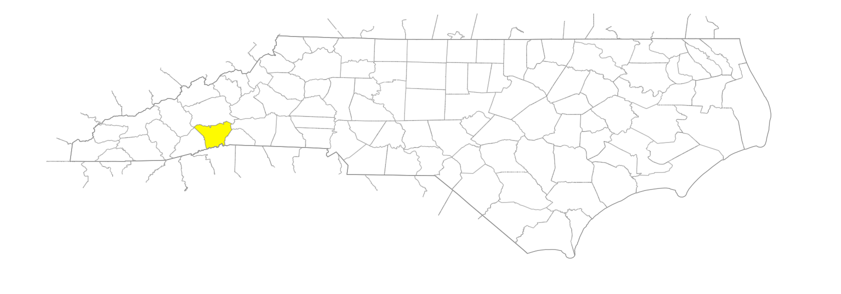
NC Gazetteer

Henderson County

… was formed in 1838 from Buncombe County. Located in the W section of the state, it is bounded by the state of South Carolina and by Transylvania, Haywood, Buncombe, McDowell, Rutherford, and Polk Counties. It was named for Leonard Henderson (1772-1833), chief justice of the N.C. Supreme Court. Area: 382 sq. mi. County seat: Hendersonville, with an elevation of 2,146 ft. Townships are Clear Creek, Crab Creek, Edneyville, Green River, Hendersonville, Hoopers Creek, Mills River, North Blue Ridge, and South Blue Ridge. Produces apples, corn, hay, snap beans, cattle, paper products, outdoor lights, electronics, tools, limestone, granite, and clay.

areas

Dark Corner
Flatwoods, The
Speculation Land

balds

Stony Bald

branches

Allen Branch
Bear Branch
Bee Branch
Betty Branch
Bold Branch
Brightwater Branch
Crawford Branch
Cushing Branch
Davie Branch
Fletcher Branch
Laurel Branch
Long Branch
McKinney Branch
Murray Branch
Phillips Branch
Rush Branch
Slickrock Branch
Sweetwater Branch
Woody Branch

communities

Adams Run
Angeline
Balfour
Barker Heights
Bat Cave
Baxter
Bearwallow
Blue Ridge
Bowmans Bluff
Boylston
Brickton
Cannon
Cloverdale
Dana
Davie
Delmont
Druid Hills
Dry Hill
Edneyville
Etowah
Flat Rock
Fletcher
Fountain Park
Fruitland
Gerton
Goodluck
Gypsy
Hillgirt
Holly Springs
Horace
Horse Shoe
Lead
Maxwell
Mills River
Mountain Home
Naples
Osteen
Ottanola
Roosevelt
Rugby
Saconon
Shehan
Sitton
Splendor
Tracy Grove
Tuxedo
Uno
Upward
Yale
Zirconia

coves

Boby Cove
Horse Cove
Rich Cove
Stepp's Cove

creeks

Big Creek
Big Hungry Creek
Blythe Mill Creek
Briary Creek
Britton Creek
Bryson Creek
Burns Creek
Byers Creek
Byers Creek
Cabin Creek
Cash Creek
Cherry Creek
Chestnut Creek
Clear Creek
Colt Creek
Cox Creek
Dismal Creek
Dog Creek
Featherston Creek
Findley Creek
Fletcher Creek
Folly Creek
Foster Mill Creek
Freeman Creek
Greer Creek
Harm Creek
Harper Creek
Henderson Creek
Hickory Nut Creek
Hoopers Creek
Jim Creek
Johnsons Mill Creek
Kelly Creek
King Creek
Kyles Creek
Laurel Fork Creek
Lewis Creek
Little Hungry Creek
Little Mud Creek
Little Willow Creek
Marsden Creek
McDowell Creek
Memminger Creek
Mill Creek
Mill Creek
Mill Pond Creek
Mud Creek
Murray Creek
Perry Creek
Puncheon Camp Creek
Queen Creek
Reedy Patch Creek
Rock Creek
Seniard Creek
Shaw Creek
Shephard Creek
Sitton Creek
Stone Creek
Stuart Creek
Sugarloaf Creek
Terry Creek
Toms Creek
Tumblebug Creek
Wash Creek
Wash Creek
Willow Creek
Wolfpen Creek

ditches

Johnson Drainage Ditch

elevations

Bowman Bluff
Heatherly Height
Play Rock Hill

forests

Pisgah National Forest

forks

Bad Fork
Bat Fork
Devils Fork
Rocky Fork

former communities

Dewitt
East Flat Rock
Murrayville
Ripley

freshwater areas

Pacolet Fall

gaps

Baldwin Gap
Beaverdam Gap
Beaverdam Gap
Bent Fork Gap
Clark Gap
Cragnola Gap
Cutthroat Gap
Deep Gap
Glady Fork Gap
Gladys Fork Gap
Gloucester Gap
Green River Gap
Hickory Nut Gap
Johnson Gap
Mills Gap
Mine Gap
Reedy Patch Gap
Strouph Gap
Terry Gap
Tramble Gap
Turkey Pen Gap
Yellow Gap
Young Gap

hills

Dodging Hill
Potato Hill

historical markers

C. G. Memminger historical marker
Calvary Church Episcopal historical marker
Carl Sandburg 1878-1967 historical marker
Edgar W. (Bill) Nye 1850-1896 historical marker
Flat Rock historical marker
French Broad Baptist Church historical marker
George Trenholm historical marker
Gun Shop and Forge historical marker
Howard Gap Road historical marker
Judson College historical marker
Shaws Creek Church and Camp Grounds historical marker
St. John in the Wilderness historical marker
Stoneman's Raid historical marker
Vance-Carson Duel historical marker
Wolfe's Angel historical marker

knobs

Big Knob
Bollers Knob
Brock Knob
Candler Knob
Cold Knob
Ferrin Knob
Hogback Knob
Ivy Knob
Johnson Knob
Pine Knob
Rattlesnake Knob
Shell Knob
West Knob

lakes

Edith Lake
Highland Lake
Kanuga Lake
Lake Kelly
Lake Summit
Osceola Lake

mountain features

Belmont Mountai
Black Mountain
Ferguson Peak
Hightop
Tarkiln Mountain

mountains

Ann Mountain
Annie Mountain
Bald Top Mountain
Bank Mountain
Barnwell Mountain
Barnwell Mountain
Bearwallow Mountain
Bell Mountain
Big Hungry Mountain
Bills Mountain
Blackjack Mountain
Blake Mountain
Blythe Mountain
Bradley Mountain
Bryson Mountain
Burl Mountain
Burney Mountain
Burntshirt Mountain
Butler Mountain
Butt Mountain
Butt Mountain
Buttermilk Mountain
Byers Mountain
Cane Mountain
Cantrell Mountain
Chickasaw Knobs
Cliffield Mountain
Corbin Mountain
Corncob Mountain
Couch Mountain
Cunningham Mountain
Davenport Mountain
Davie Mountain
Double Head
Evans Mountain
Face Rock
Forge Mountain
Forked Mountain
Frank Mountain
Garren Mountain
Glassy Rock
Graham Mountain
Grassy Mountain
Great Mountain
Green Mountain
Hammond Mountain
Hebron Mountain
Hickory Mountain
Highpeak
Hogback Mountain
Horse Pen Mountain
Horse Shoe Mountain
Huckleberry Mountain
Jumpoff Mountain
King Mountain
Lamb Mountain
Laurel Mountain
Lewis Mountain
Little Bearwallow Mountain
Little Mountain
Little Pisgah Mountain
Little Rich Mountain
Long John Mountain
Love Mountain
Mackerel Mountain
McAlpine Mountain
Mills Mountain
Mine Mountain
Mitchell Mountain
Pilot Mountain
Piney Mountain
Piney Mountain
Pinnacle Mountain
Point Lookout Mountain
Queen Creek Mountain
Raven Rock
Rich Gap Mountain
Rich Mountain
Rocky Mountain
Rush Mountain
Saluda Mountain
Sand Flat Mountain
Shepherd Mountain
Smoky Mountain
Standingstone Mountain
Stone Mountain
Stoney Mountain
Sugarloaf Mountain
Teneriffe Mountain
Trenholm Mountain
Underwood Mountain
Vance Mountain
Ward Mountain
Weed Patch Mountain
Wethero Mountain
Whiteside Mountain
Wolf Mountain

regions

Appalachian Dialect Region

ridges

Beetree Ridge
Big Ridge
Dividing Ridge
Grindstone Ridge
Huckleberry Ridge
Laurel Ridge
Little Pisgah Ridge
Marshall Ridge
Mining Ridge
Rocky Ridge
Trace Ridge

rivers

Green River
Mills River
Pacolet River

rocks

Jumpoff Rock
Wildcat Rock

schools

East Henderson High School
Henderson County Career Academy
Henderson County Early College
Hendersonville High School
North Henderson High School
West Henderson High School

shoals

Buck Shoal

tops

Chestnut Top
Double Top

towns

Hendersonville
Laurel Park

townships

Clear Creek Township
Crab Creek Township
Edneyville Township
Green River Township
Hendersonville Township
Hoopers Creek Township
Mills River Township
North Blue Ridge Township
South Blue Ridge Township

valleys

Moore Cove

waterfalls

Shoal Creek Falls