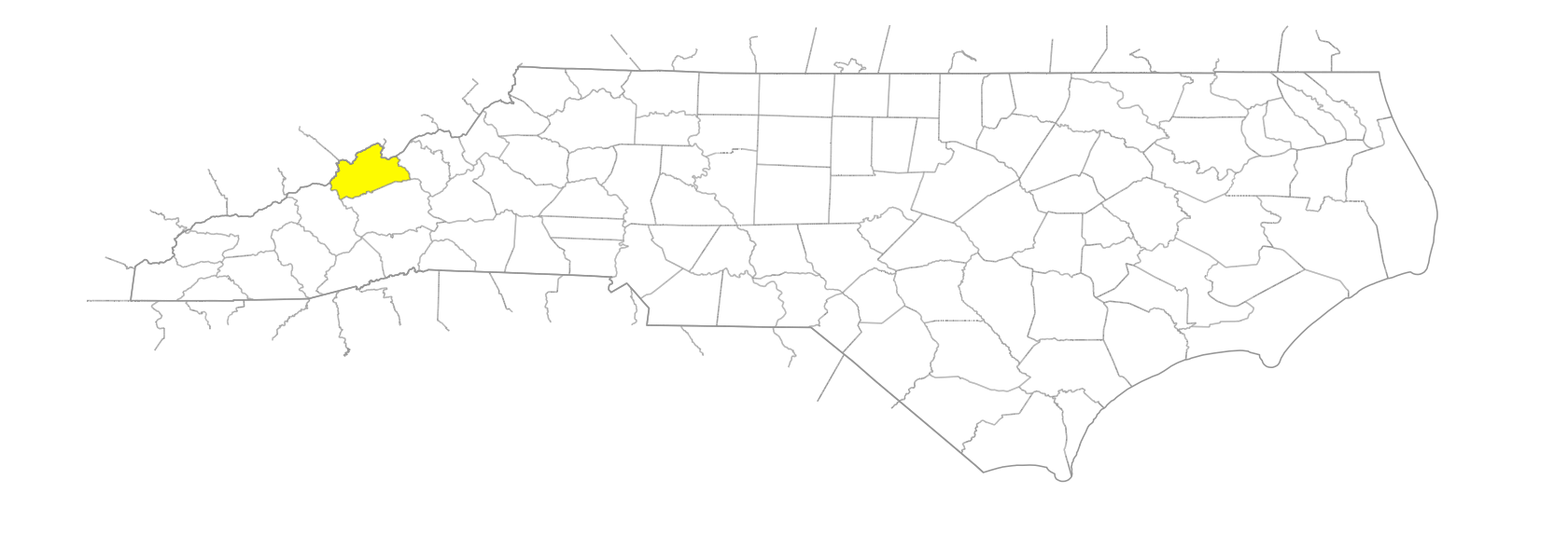
NC Gazetteer

Madison County

… was formed in 1851 from Buncombe and Yancey Counties. Located in the W section of the state, it is bounded by Yancey, Buncombe, and Haywood Counties and the state of Tennessee. It was named for James Madison (1751-1836), fourth president of the United States. Area: 456 sq. mi. County seat: Marshall, with an elevation of 1,650 ft. Townships, now numbered 1 to 16, were formerly Marshall, Shelton Laurel, Bull Creek, Middle Fork of Ivy, West Fork of Ivy, Sandy Mush, Little Pine Creek, Spring Creek, Hot Springs, Big Laurel, Upper Laurel, Big Pine Creek, Meadow Fork of Spring Creek, Grapevine, Mars Hill, and Foster Creek. Produces tobacco, corn, dairy products, livestock, hay, nursery products, pumpkins, tomatoes, textiles, and electronics.

balds

Camp Creek Bald
Little Sandy Mush Bald
Sandy Mush Bald

branches

Allman Branch
Allman Branch
Ammons Branch
Anderson Branch
Anderson Cove Branch
Arington Branch
Auston Branch
Bailey Branch
Bailey Branch
Bailey Branch
Bakers Branch
Bald Branch
Barnes Branch
Baxter Branch
Bear Branch
Bear Branch
Bear Branch
Bear Pen Branch
Bear Wallow Branch
Bee Branch
Big Branch
Big Branch
Big Rocky Branch
Bone Camp Branch
Brack Branch
Briar Patch Branch
Buckner Branch
Caldwell Branch
Callahan Branch
Caney Fork Branch
Cascade Branch
Cat Pen Branch
Charley Branch
Charlotte Branch
Clear Branch
Clover Branch
Cold Spring Branch
Cook Branch
Crane Branch
Cutshall Branch
Davis Branch
Davis Cove Branch
Doe Branch
Duckmill Branch
Fall Branch
Ferry Branch
Flea Branch
Flint Level Branch
Former Camp Branch
Fox Branch
Georgia Branch
Granger Branch
Greasy Branch
Gunter Branch
Hampton Branch
Hensley Branch
Hickory Log Branch
Hickory Ridge Branch
High Shoals Branch
Holcombe Branch
Holland Branch
Hopewell Branch
Hopis Branch
Horse Branch
Hunter Branch
Indian Camp Branch
Jacks Branch
Jarvis Branch
Jasperfield Branch
John Taylor Branch
Johns Branch
Johnson Branch
Jones Branch
Levy Branch
Lewis Branch
Lisenbee Branch
Little Bald Branch
Little Bottom Branch
Long Branch
Long Branch
Long Branch
Long Mountain Branch
Maple Spring Branch
Martin Branch
Morrow Branch
Mountain Island Branch
Murray Branch
Palmer Camp Branch
Panther Branch
Pine Branch
Ponder Branch
Pounding Mill Branch
Pump Branch
Puncheon Camp Branch
Raccoon Branch
Rector Branch
Reddy Branch
Reems Branch
Reservoir Branch
Revis Branch
Rice Branch
Robert Branch
Rock Branch
Rockhouse Branch
Rocky Branch
Rocky Branch
Shade Branch
Shook Branch
Silvermine Branch
Simmons Branch
Skiffly Branch
Smith Branch
Sodom Branch
Spout Branch
Sprinkle Branch
Squirrel Branch
Steve Branch
Stillhouse Branch
Sugar Camp Branch
Sweetwater Branch
Teat Branch
Thomas Branch
Tillery Branch
Trent Branch
Turkey Cove Branch
Walnut Cove Branch
Watermelon Branch
White Rock Branch
Wild Branch
Wild Branch
Wilson Branch
Wolf Branch
Woodson Branch
Wooleyshot Branch
Woolsey Branch
Worley Cove Branch

communities

Allanstand
Allegheny
Barnard
Beech Glen
Belva
Big Laurel
Big Pine
Bluff
Briggsville
Buckner
California
Carmen
Cross Rock
Cutshalltown
Doe Branch
Druid
English
Faust
Forks of Ivy
Friezeland
Gallagans
Grantville
Guntertown
Hale Wood
Holcombe
Ivy
Joe
Just
Kalamazoo
Kind
Laurel
Laurelton
Leonard
Little Creek
Luck
Lumptown
Lynch
Meadows Store
Nocona
Outlook
Paint Fork
Paint Rock
Peek
Petersburg
Protection
Pump
Ray
Redmon
Revere
Rollins
Runion
Sandy Bottom
Sexton
Shaleville
Shelton Laurel
Sodom
Spring Creek
Stackhouse
Tennelina
Theta
Trailbranch
Trust
Verd
Walnut
Walnut Creek
Walnut Run
Waverly
Worley

coves

Stevens Cove
Worley Cove

creeks

Allan Creek
Amos Creek
Bear Creek
Bearpen Creek
Beetree Creek
Big Creek
Big Laurel Creek
Big Pine Creek
Brush Creek
Bull Creek
California Creek
Chandler Creek
Chimney Creek
Colvin Creek
Crooked Creek
Dry Creek
East Fork Shut-in Creek
Foster Creek
Fox Creek
Friezeland Creek
Gabriels Creek
Grassy Creek
Heck Creek
Hunter Creek
Hurricane Creek
Ivy Creek
Little Creek
Little Creek
Little Creek
Little Foster Creek
Little Hurricane Creek
Little Ivy Creek
Little Laurel Creek
Little Pine Creek
Little Sandymush Creek
Mill Creek
Norton Fork Creek
Panhandle Creek
Pawpaw Creek
Peter Cove Creek
Ponder Creek
Puncheon Fork Creek
Revere Creek
Rice Cove Creek
Shelton Laurel Creek
Shut-in Creek
Sliding Knob Creek
Spillcorn Creek
Spring Creek
Sprinkle Creek
Turkey Creek
Walnut Creek
West Fork Shut-in Creek
Whiteoak Creek

forests

Pisgah National Forest

forks

East Fork [Bull Creek]
Hickory Fork
Meadow Fork
Middle Fork
North Fork [Big Pine Creek]
Paint Fork
Roaring Fork
Roaring Fork
South Fork [Big Pine Creek]
Terris Fork
West Fork [Bull Creek]

former communities

Big Laurel Township
Big Pine Creek Township
Bull Creek Township
Foster Creek Township
Grapevine Township
Hot Springs Township
Little Pine Creek Township
Mars Hill Township
Marshall Township
Meadow Fork of Spring Creek Township
Middle Fork of Ivy Township
Sandy Mush Township
Shelton Laurel Township
Spring Creek Township
Upper Laurel Township
West Fork of Ivy Township

gaps

Beer Rice Gap
Betsey Gap
Boone Cove Gap
Bull Creek Gap
Chestnut Gap
Chestnut Log Spring Gap
Coley Gap
Davidson Gap
Devils Fork Gap
Doggett Gap
Dogwood Gap
Fox Cabin Gap
Hickory Gap
Huckleberry Gap
Ivy Gap
Kate Gap
Lemon Gap
Lick Log Gap
Little Creek Gap
Little Pine Gap
Little Sandy Gap
Maney Gap
Maple Spring Gap
Mary Gap
Meadow Fork Gap
Meadow Gap
Miles Gap
Moccasin Gap
Moody Gap
Moore Gap
Murray Gap
Norton Fork Gap
Old Station Gap
Oldfield Gap
Paint Gap
Pleasant Gap
Potato Gap
Ramsey Gap
Robert Gap
Seng Gap
Spring Creek Gap
Squirrels Gap
Street Gap
Sugartree Gap
Tanyard Gap
Turkey Cove Gap
Walnut Gap
Walnut Gap
Whiteoak Gap

historical markers

Balladry historical marker
Bascom Lamar Lunsford historical marker
Frances Goodrich 1856-1944 historical marker
Hot Springs historical marker
Mars Hill College historical marker
Paint Rock historical marker
Shelton Laurel Massacre historical marker

islands

Bartleys Island
Blennerhassett Island
Cane Island
Huff Island

knobs

Alum Knob
Bald Knob
Big Knob
Big Knob
Big Knob
Bucks Knob
Carver Knob
Cedar Knob
Chandler Knob
Dans Knob
Devil Knob
Dicks Knob
Doggett Knob
Elk Wallow Knob
Frozen Knob
Grassy Knob
Gravel Knob
Gunter Knob
Hack Gap Knob
High Knob
Hookers Knob
Huckleberry Knob
Lamb Knob
Little Knob
Lone Knob
Mary Knob
Mikes Knob
Moody Knob
Oak Knob
Panther Knob
Pilot Knob
Pug Knob
Red Hill Knob
Rich Knob
Rocky Knob
Rocky Knob
Rough Knob
Slaty Knob
Stiff Knee Knob
Sugarloaf Knob
Upper Haw Knob
Walnut Knob
Walnut Knob
Wiley Knob
Zade Knob

mountain features

Arm, The
Big Butt
Rector Butte
Stony Spur
White Rock Cliffs

mountain ranges

Bald Mountains
Sheridan Mountains
Woodard Mountains

mountains

Barnett Mountain
Berry Mountain
Bluff Mountain
Broom Straw Mountain
Butte Mountain
Chestnut Mountain
Coldspring Mountain
Dan Payne Mountain
Deer Park Mountain
Divide Mountain
Dixon Mountain
Doctor Mountain
Dog Ridge Mountain
Ephraim Hensley Mountain
Fork Legged Mountain
Fork Mountain
Foxtown Mountain
Granger Mountain
Hap Mountain
Hebo Mountain
Hickory Bearpen Mountain
Hickory Spur
High Rock
Hog Back Mountain
Hogback Mountain
Hop Mountain
Hot Springs Mountain
Jack Trail Mountain
Jarvis Mountain
Lonesome Mountain
Long Mountain
Loviade Mountain
Max Patch Mountain
Meadow Fork Mountain
Nofat Mountain
Peter Cove Mountain
Pine Mountain
Pine Mountain
Potato Lump Mountain
Rhody Franklin Mountain
Roaring Fork Mountain
Robinson Rough
Round Top Mountain
Sally Mountain
Sam Doane Mountain
Sapling Mountain
Snake Den Mountain
Sodom Mountain
Spring Creek Mountain
Spring Mountain
Stony Mountain
Sugarloaf Mountain
Turkey Mountain
Watershed Mountain
Wolf Mountain

points

Snaggy Point

prongs

East Prong [Hickory Fork]
West Prong [Hickory Fork]

regions

Appalachian Dialect Region

ridges

Alum Ridge
Bailey Ridge
Bearpen Ridge
Black Pine Ridge
Brushy Ridge
Buckeye Ridge
Buna Ridge
Carter Mill Ridge
Dry Pond Ridge
Gladden Ridge
Golden Ridge
Grapevine Ridge
Grass Land Ridge
Greene Ridge
High Ridge
High Rock Ridge
John Anders Ridge
Laurel Ridge
Lead Mine Ridge
Lisenbee Ridge
Little Middle Ridge
Lovers Leap Ridge
Middle Ridge
Mill Ridge
Mine Ridge
Orchard Ridge
Partridge Gap Ridge
Pilot Ridge
Rich Ridge
Rocky Ridge
Seng Ridge
Seven Mile Ridge
Shinbone Ridge
Turkeypen Ridge

rivers

Ivy River

rocks

Lick Rock

runs

Hayes Run

schools

Madison Early College High
Madison High School
Mars Hill School

tops

Duckett Top

towns

Hot Springs
Huntsborough
Mars Hill
Marshall
Spaightville

valleys

Brigman Hollow
Polecat Hollow