NC Gazetteer

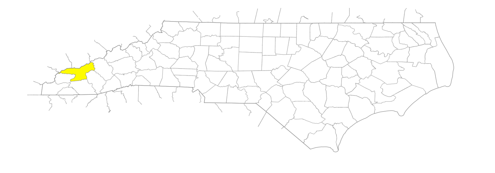
Swain County

… was formed in 1871 from Jackson and Macon Counties. Located in the SW section of the state, it is bounded by the state of Tennessee and by Graham, Cherokee, Macon, Jackson, and Haywood Counties. It was named for David L. Swain (1801-68), governor of the state and president of the University of North Carolina. Area: 544 sq. mi. County seat: Bryson City, with an elevation of 1,736 ft. Townships are Charleston, Forneys Creek, and Nantahala. The Qualla Boundary of the Cherokee Indians, Great Smoky Mountains National Park, Nantahala National Forest, and Fontana Lake occupy much of Swain County. Produces corn, poultry, livestock, furniture, textiles, apparel, leather goods, gaming proceeds, hay, candy, crushed stone, and feldspar.
areas

Huggins Hell
Lawson Gant Lot
Nick Bottom
Pigpen Flats
Spence Field
Upper Flats
Whiteoak Flats

balds

Andrews Bald
Bearwallow Bald
Becks Bald
Big Bald
Big Bald
Big Chestnut Bald
Buckhorn Bald
Bunches Bald
Cheoah Bald
Davis Bald
De Armond Bald
De Hart Bald
Flat Creek Bald
Gregory Bald
Heintooga Bald
Hyatt Bald
Jerry Bald
Ledge Bald
Little Chestnut Bald
Lowing Bald
Nettle Creek Bald
Newton Bald
Parson Bald
Peaks Bald
Potato Hill Bald
Shepherd Bald
Silers Bald
Soco Bald
Swim Bald
Welch Bald

bends

Horseshoe Bend
Horseshoe Bend

branches

Advalorem Branch
Aiken Branch
Ammons Branch
Andreas Branch
Anthony Branch
Arlington Branch
Augerhole Branch
Ayden Branch
Bald Branch
Bald Branch
Balsam Branch
Bearmeat Branch
Bearpen Branch
Bearpen Branch
Bearwallow Branch
Becks Branch
Bee Gum Branch
Bee Gum Branch
Betts Branch
Big Branch
Big Flats Branch
Big Head Branch
Birchfield Branch
Board Cove Branch
Boomer Branch
Breedlove Branch
Brewer Branch
Brushy Branch
Bryson Branch
Buckeye Branch
Buckhorn Branch
Buckner Branch
Bumgardner Branch
Cabe Branch
Cabin Branch
Cabin Branch
Calhoun Branch
Calhoun Branch
Camp Branch
Canebrake Branch
Charley Branch
Cheoah Branch
Cherry Branch
Chesquau Branch
Chokeberry Branch
Clark Branch
Cliff Branch
Cochran Branch
Cold Spring Branch
Coldspring Branch
Coldspring Branch
Cope Branch
Cullasaja Branch
Dalton Branch
Dark Branch
Davis Branch
De Hart Branch
De Hart Branch
Deals Branch
Deep Gap Branch
Defeat Branch
Desolation Branch
Durham Branch
Elbow Branch
Estes Branch
Falls Branch
Falls Branch
First Hurricane Branch
Fishtrap Branch
Flat Branch
Fox Branch
Frisbee Branch
Galamore Branch
Georges Branch
Gibby Branch
Gibby Branch
Glady Branch
Goldmine Branch
Grassy Branch
Grassy Branch
Grassy Branch
Greasy Branch
Greer Branch
Hammer Branch
Haw Gap Branch
Hickory Flat Branch
Hickory Flat Branch
Hickorynut Branch
Huggins Branch
Hughes Branch
Hurricane Branch
Hyatt Branch
Jack Bradley Branch
Jake Branch
Jenkins Branch
Jenny Branch
Johnson Branch
Judy Branch
Juney Whank Branch
Keg Drive Branch
Lambert Branch
Laurel Branch
Laurel Branch
Laurel Branch
Laurel Branch
Laurel Gap Branch
Lawson Gant Lot Branch
Long Branch
Long Branch
Louie Camp Branch
Lower Grassy Branch
Lynn Branch
Madcap Branch
Marr Branch
Mason Branch
Matt Branch
McGee Branch
McHan Branch
Messer Branch
Mill Branch
Mill Branch
Moody Branch
Moore Branch
Moore Springs Branch
Mudcut Branch
Myers Branch
Nunda Branch
Owl Branch
Painter Branch
Payne Branch
Pine Gap Branch
Pleasant Branch
Pole Bridge Branch
Pole Bridge Branch
Poplar Hollow Branch
Proctor Branch
Proctor Sang Branch
Quillaree Branch
Rock Camp Branch
Rock Camp Branch
Roses Branch
Rowan Branch
Rye Patch Branch
Salola Branch
Sandy Gap Branch
Second Hurricane Branch
Sherrill Cove Branch
Siles Branch
Silvermine Branch
Simmons Branch
Skidder Branch
Slab Camp Branch
Slipoff Branch
Smith Branch
Soapstone Branch
Soggy Hill Branch
Spread Branch
Stevenson Branch
Stratton Branch
Sweet Branch
Table Rock Branch
Tabor Branch
Talc Mountain Branch
Tarkiln Branch
Teds Branch
Tennessee Branch
Thicket Branch
Thompson Branch
Toot Hollow Branch
Townhouse Branch
Trap Branch
Tuneigh Branch
Tunnel Branch
Weaver Branch
Welch Branch
Welch Branch
Welch Branch
White Walnut Branch
Whiteoak Branch
Wiggins Branch
Wildcat Branch
Will Branch
Williams Branch
Wooly Ridge Branch
Worley Branch
Yellow Branch

communities

Alarka
Almond
Big Laurel
Birdtown
Ela
Epps Springs
Fairfax
Governors Island
Hewitt
Lauada
Maple Springs
Nantahala
Pocahontas
Ravens
Ravensford
Smokemont
Solola Valley
Swayney
Talc Mountain
Unahala
Wesser

coves

Battle Cove
Big Cove
Billy Cove
Chestnut Cove
Coot Cove
Dog Cove
Elliott Cove
Euchulla Cove
Flower Cove
Fowler Cove
Gibson Cove
Grape Cove
Grill Cove
Hickory Cove
Hickory Cove
Hickory Cove
Horse Cove
Improvement Cove
Johns Cove
Long Cove
Lynn Cove
Martin Cove
Milksick Cove
Miller Cove
Odear Cove
Old Cove
Phipps Cove
Poplar Cove
Poplar Cove
Turkey Cove

creeks

Adams Creek
Balsam Corner Creek
Battle Creek
Bear Creek
Beetree Creek
Big Creek
Board Camp Creek
Bone Valley Creek
Bowers Creek
Bridge Creek
Brush Creek
Bulldie Creek
Bunches Creek
Chambers Creek
Chasteen Creek
Cherry Creek
Chestnut Cove Creek
Clingmans Creek
Collins Creek
Connelly Creek
Cooper Creek
Couches Creek
Dans Creek
Davis Creek
De Hart Creek
Deep Creek
Eagle Creek
Ekaneetlee Creek
Enloe Creek
Flat Creek
Forney Creek
Galbreath Creek
Goose Creek
Gray Wolf Creek
Gunna Creek
Hazel Creek
Heintooga Creek
Huggins Creek
Huskey Creek
Hyatt Creek
Improvement Creek
Indian Creek
Indian Creek
Jonas Creek
Jones Creek
Jones Creek
Kirkland Creek
Kirkland Creek
Lands Creek
Ledbetter Creek
Ledge Creek
Little Jonas Creek
Little Laurel Creek
Little Steeltrap Creek
Little Yalaka Creek
Long Creek
Lost Cove Creek
Middle Peachtree Creek
Mill Creek
Mingo Creek
Mingus Creek
Nettle Creek
Noland Creek
Pawpaw Creek
Peachtree Creek
Pigeon Creek
Pigeon Creek
Pilkey Creek
Piney Wood Creek
Pinnacle Creek
Pole Road Creek
Proctor Creek
Queens Creek
Rattlesnake Creek
Redman Creek
Roaring Creek
Round Bottom Creek
Sahlee Creek
Sawmill Creek
Scarlet Ridge Creek
Selma Creek
Shepherd Creek
Silvermine Creek
Steeltrap Creek
Stillwell Creek
Taywa Creek
Tow String Creek
Tub-Mill Creek
Twentymile Creek
Una Creek
Upper Long Creek
Walkers Creek
Watia Creek
Wesser Creek
Wesser Creek
White Mans Glory Creek
Whiteside Creek
Wiggins Creek
Wild Cherry Creek
Yalaka Creek

forests

Nantahala National Forest

forks

Bradley Fork
East Fork [Kirkland Creek]
Kanati Fork
Left Fork [Deep Creek]
Left Fork [Indian Creek]
Left Fork [Raven Fork]
Left Fork [Redman Creek]
Middle Fork [Raven Fork]
North Fork [Chambers Creek]
Raven Fork [Oconaluftee River]
Right Fork [Cold Spring Branch]
Right Fork [Indian Creek]
Right Fork [Raven Fork]
Right Fork [Redman Creek]
Right Fork [Wesser Creek]
Rock Fork
Straight Fork
Sugar Fork
West Fork [Kirkland Creek]

former communities

Bushnell
Collinwood
Dorsey
Ecola
Fontana
Forney
Fry
Hubbard
Judson
Marcus
Medlin
Needmore
Noland
Proctor
Ritter
Wayside

gaps

Bearpen Gap
Bearpen Gap
Beech Gap
Beechnut Gap
Bellcollar Gap
Big Abrams Gap
Big Witch Gap
Birch Spring Gap
Black Camp Gap
Blazed Gap
Board Camp Gap
Brier Lick Gap
Broke Yoke Gap
Brushy Gap
Buck Gap
Buckeye Gap
Chambers Creek Gap
Cherokee Gap
Cherry Gap
Cold Spring Gap
Collins Gap
Copper Gap
Dalton Gap
Davis Gap
De Lozier Gap
Deals Gap
Deep Creek Gap
Deep Gap
Deep Gap
Deep Gap
Deep Gap
Deeplow Gap
Dry Sluice Gap
Easy Ridge Gap
Ekaneetlee Gap
Evans Gap
False Gap
Fox Gap
Grassy Gap
Grassy Gap
Gunter Gap
Haw Gap
Hewitt Gap
Hickory Nut Gap
Hightower Gap
Hogback Gap
Horse Creek Gap
Indian Gap
Indian Grave Gap
Indian Grave Gap
Laurel Gap
Leatherman Gap
Ledge Gap
Licklog Gap
Little Abrams Gap
Locust Gap
Low Gap
Lower Sassafras Gap
Luftee Gap
Martins Gap
Massie Gap
Meadow Gap
Mineral Gap
Mud Gap
Mule Gap
Newfound Gap
Pauls Gap
Peachtree Gap
Pickens Gap
Pilot Gap
Pin Oak Gap
Porters Gap
Red Ridge Gap
Rich Gap
Robinson Gap
Roses Gap
Sally Gap
Sams Gap
Sassafras Gap
Sheep Pen Gap
Sherrill Gap
Sherrill Gap
Shular Gap
Siles Gap
Silvermine Gap
Sluice Gap
Starkey Gap
Sugartree Gap
Tali Gap
Terrell Gap
Turkey Cove Gap
Tuskee Gap
Una Gap
Upper Sassafras Gap
Walker Gap
Water Oak Gap
Wesser Gap
Wilkie Gap
Will Gap
Windy Gap

geological formations

Nantahala Gorge

hills

Potato Hill
Round Hill

historical markers

Cherokee Indian Reservation historical marker
Deep Creek historical marker
Ellen Black Winston 1903-1984 historical marker
Horace Kephart historical marker
Kituwah historical marker
Nimrod Jarrett Smith 1837-1893 historical marker
Thomas's Legion historical marker
Tsali historical marker
William Bartram historical marker
Yonaguska ca. 1760-1839 historical marker

islands

Governors Island

knobs

Barnett Knob
Bee Knob
Blackrock Knob
Brier Knob
Caler Knob
Cherry Knob
Coburn Knob
Cold Spring Knob
Doe Knob
Evans Knob
Fern Knob
Forge Knob
Greer Knob
Hawk Knob
Hemlock Knob
Hickorynut Knob
Leatherman Knob
Locust Knob
Luftee Knob
Marks Knob
Masa Knob
McCampbell Knob
McHan Knob
Mica Knob
Ogle Knob
Phillip Knob
Pilot Knob
Pinnacle Knob
Pond Knob
Powell Knob
Rattlesnake Knob
Rocky Knob
Round Mountain Knob
Roundtop Knob
Sassafras Knob
Scott Knob
Shear Knob
Sheep Knob
Sheep Wallow Knob
Shope Knob
Slipoff Knob
Soapstone Knob
Strawberry Knob
Suli Knob
Tricorner Knob
Tyre Knob
Whim Knob
Wolf Knob
Woodward Knob
Worley Knob

lakes

Ela Lake
Fontana Lake
Lake Cheoah

mountain features

Barker Butt
Cedar Cliff
High Rocks
Nantahala Mountain Range
Noland Divide
Saddleback
Sawteeth, The

mountain ranges

Cowee Mountains
Yalaka Mountains

mountains

Baines Mountain
Balsam Corner
Balsam Mountain
Big Swag
Blockhouse Mountain
Briertown Mountain
Buzzardroost Mountain
Cataloochee Balsam
Charlies Bunion Mountain
Chiltoes Mountain
Clingmans Dome
Collins Mountain
Connelly Mountain
Cooper Mountain
Cowstamp Mountain
Devils Race Patch
Devils Tater Patch
Eagle Rock
Fork Mountain
Fork Mountain
Fry Mountain
Hickorynut Mountain
Hurricane Mountain
Jackson Line Mountain
Jump-up, The
Leatherman Mountain
Little Shuckstack
Matt Mountain
Mine Mountain
Mount Buckley
Mount Chapman
Mount Collins
Mount Davis
Mount Glory
Mount Hardison
Mount Kephart
Mount Love
Mount Noble
Mount Sequoyah
Mount Squires
Mount Yonaguska
Paint Mountain
Pecks Corner
Rattlesnake Cliff
Rattlesnake Mountain
Raven Den
Raven Mountain
Rich Mountain
Richland Mountain
Rocky Face Mountain
Shuckstack Mountain
Spruce Mountain
Thunderhead Mountain
Una Mountain

parks

Great Smoky Mountains National Park

points of interest

Sugartree Licks

prongs

Beech Flats Prong
Chasm Prong
Gulf Prong
Kephart Prong
Left Prong [Bridge Creek]
Right Prong [Ledge Creek]

regions

Appalachian Dialect Region

ridges

Ace Enloe Ridge
Asgini Ridge
Bald Ridge
Balsam Ridge
Bearpen Ridge
Bearwallow Ridge
Bee Ridge
Beetree Ridge
Big Fork Ridge
Big Grill Ridge
Blockhouse Ridge
Breakneck Ridge
Buckhorn Ridge
Bulldie Ridge
Bumgardner Ridge
Burnt Spruce Ridge
Chestnut Ridge
Dalton Ridge
Dashoga Ridge
De Armond Ridge
Devils Court House Ridge
Easy Ridge
Elbow Ridge
Enloe Ridge
Firescald Ridge
Fork Ridge
Fork Ridge
Forney Ridge
Forrester Ridge
Gibson Ridge
Gunlock Ridge
Hawk Ridge
Hayes Ridge
Heintooga Ridge
High Rock Ridge
Highland Ridge
Horse Ridge
Horseshoe Ridge
Horseshoe, The
Horsetrough Ridge
Huggins Ridge
Hughes Ridge
Hurricane Ridge
Hyatt Ridge
Indian Ridge
Ivy Ridge
Jenkins Trail Ridge
Jerry Bald Ridge
Jumpup Ridge
Katalsta Ridge
Killpecker Ridge
Little Chestnut Ridge
Little Grill Ridge
Locust Ridge
Loggy Ridge
Lone Pine Ridge
Long Cove Ridge
Long Drive Ridge
Long Hungry Ridge
Long Ridge
Loudermilk Ridge
Middle Fork Ridge
Middle Ridge
Mine Ridge
Nuna Ridge
Overlook Ridge
Paw Paw Ridge
Pilot Ridge
Piney Ridge
Pinnacle Ridge
Proctor Ridge
Rapid Creek Ridge
Rattlesnake Ridge
Raven Ridge
Raven Roost Ridge
Red Ridge
Redman Ridge
Rocky Fork Ridge
Rough-hew Ridge
Round Mountain
Sawbrier Ridge
Scarlet Ridge
Shawano Ridge
Shot Beech Ridge
Shuckstack Ridge
Snakeden Ridge
Snakeden Ridge
Starkey Ridge
Stony Mountain Ridge
Suli Ridge
Sunkoto Ridge
Thomas Ridge
Tunnel Ridge
Twentymile Ridge
Wasulu Ridge
Welch Ridge
Whiteoak Ridge
Wild Cherry Ridge
Wolf Ridge
Woolly Ridge
Yanu Ridge

rivers

Little Tennessee River
Nantahala River
Oconaluftee River

rocks

Raven Rock

runs

Rock Camp Run

schools

Cherokee High School
Swain County High School

springs

Blowing Spring
McGee Spring

tops

Balsam High Top
Grassy Top
Laurel Top
Rocky Top
Round Top
Sharp Top

towns

Bryson City
Cherokee
Whittier

townships

Charleston Township
Forneys Creek Township
Nantahala Township
Oconalufty Township

transportation-related places

Halls Ford

valleys

Adams Hollow
Bone Valley
Hamilton Hollow
Hickory Bottom
McHan Cove
Possum Hollow