NC Gazetteer

Carteret County

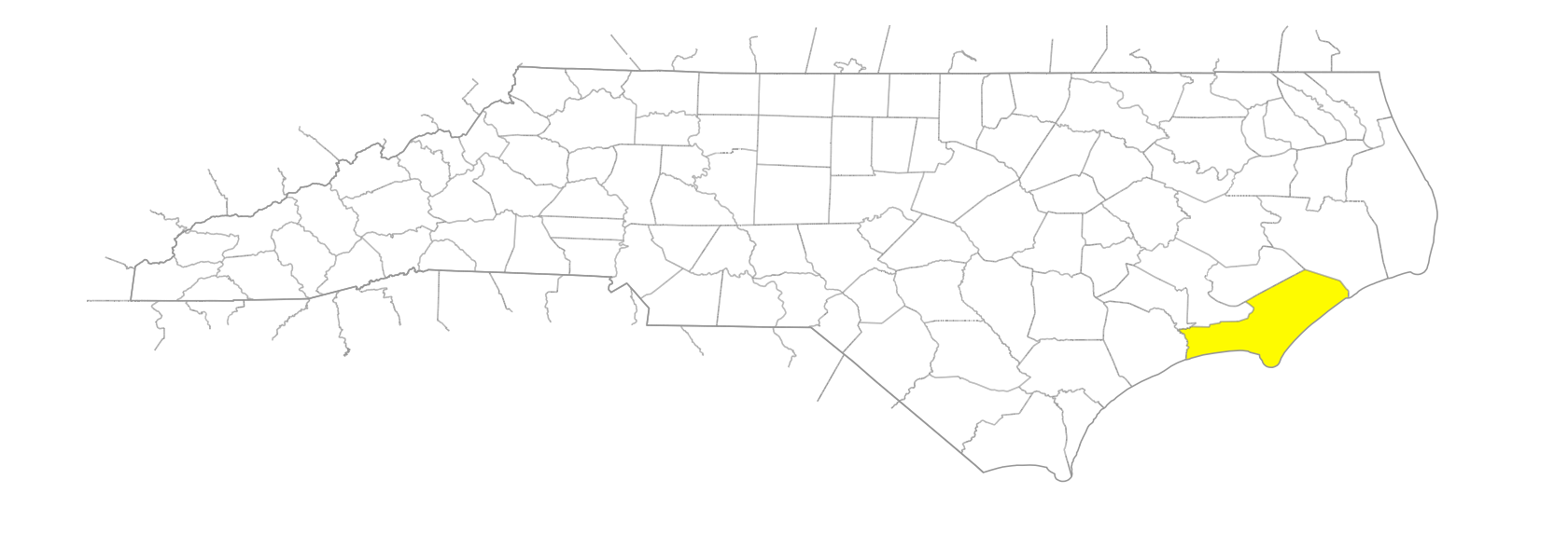
… was formed in 1722 from Craven County. Located in the E section of the state, it is bounded by the Atlantic Ocean, by Onslow, Jones, and Craven Counties, and by Neuse River and Pamlico Sound. Bogue and Core Sounds separate the Outer Banks from the mainland of the county. It was named for John Carteret (1690-1763), later second Earl Granville, one of the Lords Proprietors. Area: 1,063 sq. mi. (532, land; 531, water). County seat: Beaufort, with an elevation of 9 ft. Townships are Beaufort, Cedar Island, Davis, Harkers Island, Merrimon, Harlowe, Marshallberg, Morehead, Newport, Portsmouth, Smyrna, Straits, and White Oak. Produces corn, soybeans, Irish potatoes, Irish potatoes, hogs, apparel, boxes, boats, and seafood.
areas

Cotton Hammock
Open Land
Rich Hammock

bays

Abraham Bay
Back Bay
Barry Bay
Brett Bay
Casey Bay
Cedar Bay
Cedar Island Bay
Chadwick Bay
Cheney Bay
Crab Point Bay
East Bay
Eastmouth Bay
Goose Bay
Great Island Bay
Half-Moon Bay
Hancock Bay
Hills Bay
Hog Island Bay
Hogpen Bay
Horton Bay
Jacks Bay
Jarrett Bay
Koonces Bay
Long Bay
Lookout Bight
Merkle Bay
Money Island Bay
Mulberry Bay
Mullet Pond
Nelson Bay
North Bay
North Bay
Pettivers Bay
Raleigh Bay
Rattan Bay
Rumley Bay
South Bay
Spit Bay
Styron Bay
Tar Landing Bay
Taylor Bay
Thorofare Bay
Turnagain Bay
Wade's Shore
West Bay
West Thorofare Bay
Westmouth Bay

beaches

Core Beach

branches

Billy's Branch
Caleb Branch
Citte Weeks Branch
Northeast Branch [Newport River]
School House Branch
Shoe Branch
Sikes Branch
Southwest Prong Branch

businesses or business districts

Crystal Coast

canals

Camp Canal

channels

Banks Channel
Blair Channel
Burthen Channel
Crab Point Thorofare
Croaker Channel
Gallants Channel
Half-Moon Channel
Harbor Channel
Hoyts Stop
Main Channel
Swash, The
Wallace Channel

cities

Carolina City

communities

Bettie
Bogue
Bucks Corner
Cedar Island
Cedar Point
Davis
Edgewater
Gloucester
Goodwin Hills
Harlowe
Ho-Ho Village
Holly Springs
Hollywood
Kuhns
Lola
Mansfield
Marshallberg
Masontown
Merrimon
Mill Creek
Mitchell
Morgantown
Ocean
Otway
Peletier
Roe
Salter Path
Sealevel
Smyrna
South River
Stacy
Stella
Straits
Wildwood
Williston
Winthrop

coves

Bell Cove
Bob's Cove
Graveyard Cove

creeks

Adams Creek
Back Creek
Bartrams Creek
Bell Creek
Big Creek
Black Creek
Boathouse Creek
Broad Creek
Brown Creek
Buck Creek
Cales Creek
Calico Creek
Cedar Creek
Cedar Swamp Creek
Chadwick Creek
Chesters Creek
Clubfoot Creek
Coffee Creek
Core Creek
Cullie Creek
Deep Creek
Deep Creek
Deer Creek
Deer Creek
Dixon Creek
Doe Creek
Dublin Creek
Dumplin Creek
Eastman Creek
Fraziers Creek
Fulchers Creek
Gales Creek
Garbacon Creek
Gillikin Creek
Glover Creek
Goose Creek
Great Creek
Hadnot Creek
Harlowe Creek
Hoop Pole Creek
Howland Creek
Hunters Creek
Hunting Island Creek
Johnson Creek
Lewis Creek
Little Creek
Little Deep Creek
Long Creek
Maria Creek
Middens Creek
Mill Creek
Mill Creek
Mulberry Creek
Neal Creek
Neds Creek
North Leopard Creek
Northwest Prong Creek
Old House Creek
Oyster Creek
Oyster Creek
Pasture Creek
Peletier Creek
Pettivers Creek
Pitman Creek
Point of Grass Creek
Royal Creek
Russells Creek
Salter Creek
Sanders Creek
Sandy Huss Creek
Sleepy Creek
Smyrna Creek
South Leopard Creek
Southwest Creek
Spooners Creek
Still Creek
Taylor Creek
Turnagain Creek
Turner Creek
Tusk Creek
Wade Creek
Ward Creek
Ware Creek
Willis Creek
Williston Creek
York Creek

elevations

Cape Lookout
Crow Hill
Point of Grass

forests

Croatan National Forest

forks

East Fork [South River]
Ghoul's Fork
West Fork [South River]

former communities

Carteret Township
Diamond City
Hunting Quarters Township
Lukens
Lupton

groups of islands

Dog Island
Hog Island
Middle Marshes
Swan Islands

guts

Miry Gut
Mullet Gut
Rich Island Gut

historical markers

Atlantic Hotel historical marker
Camp Glenn historical marker
Cape Lookout Lighthouse historical marker
Carolina City historical marker
Confederate Salt Works historical marker
Core Sound Meeting historical marker
Fort Hancock historical marker
Fort Macon historical marker
Hoophole Creek historical marker
Jacob Henry Ca. 1775-1847 historical marker
Marine Research historical marker
Michael J. Smith historical marker
N. C. State Highway Patrol historical marker
Newport Barracks historical marker
North Carolina Bankers Association historical marker
North Carolina National Guard historical marker
Ocracoke Inlet historical marker
Old Burying Ground historical marker
Queen Anne's Revenge historical marker
Salt Works historical marker
Siege Of Fort Macon historical marker
Spanish Attack historical marker
Ss Pevensey historical marker
Teacher's Assembly (north Carolina Education Assn.) historical marker
Union Artillery historical marker
Verrazzano historical marker
Whale Fishery historical marker

historical sites

Camp Glenn
Fort Benjamin
Fort Macon

inlets

Beaufort Inlet
Bogue Inlet
Cedar Inlet
Drum Inlet
High Hill Inlet
Hunting Quarter Inlet
Lewis Creek
Ocracoke Inlet
Piney Creek
Sanders Creek

islands

Beacon Island
Bear Island
Bells Island
Brown's Island
Carrot Island
Casey Island
Cat Island
Cedar Hammock
Cedar Island
Cedar Island
Chainshot Island
Corncob Island
Cowpen Island
Cricket Hill
Davis Island
Duges Island
Evergreen Island
Flounder Slue Rock
Fortin Island
Goat Island
Goose Island
Great Island
Gull Island
Harbor Island
Harkers Island
Horse Island
Horse Island
Hunting Island
Jones Island
Long Island
Lovett Island
Money Island
Myrtle Island
Newport Marshes
North Rock
Piney Island
Piney Island
Pivers Island
Portsmouth Island
Raccoon Key
Radio Island
Salters Lumps
Sheep Island
Shell Castle
Shell Island
Snake Island
Sugar Loaf Island
Town Marsh
Tump Island
Wainwright Island
Wococon Island
Wood Island

lakes

Ellis Lake

marshes

Point of Marsh

peninsulas

Kings Point

pocosins

Lakes Pocosin

points

Archie's Point
Ball's Point
Bells Point
Camp Point
Careening Point
Cedar Bay Point
Cedar Island Point
Cedar Island Point
Cedar Point
Cedar Point
Corn Crib Point
Crab Point
Dan Weeks Point
Drum Point
Ennetts Point
Fish Hawk Point
Gallant Point
Goose Bay Point
Green Point
Green Point
Guthrie Point
Hall Point
Hancock Point
Hickory Point
Hog Island Point
Hog Point
Horsepen Point
Horton Point
Laughton Point
Lees Point
Lenox Point
Long Point
Lookout Point
Mill Point
Mobley Point
Mulberry Point
Newstump Point
Penn Point
Piney Point
Piney Point
Procks Point
Rock Point
Royal Point
Sand Point
Sanders Point
Sandy Point
Shackleford Point
Shell Point
Shelly Point
Shepherd's Point
Shingle Point
Steep Point
Tump Point
Western Point
White Point

ponds

Great Pond
Herring Pond

populated places

Piney Point
Portsmouth
Rice Path
Sage Path

proposed places

Lenoxville

regions

Coastal Plain
Coastal Plain Dialect Region
Outer Banks
Outer Banks Dialect Region

reserves

Cape Lookout National Seashore

rivers

Laurel River
Merrimon River
Neuse River
Newport River
North River
South River
White Oak River

runs

Jump Run
Terrapin Run

sandhills

High Hills, The
Hirams Hill

schools

Bridges School
Croatan High School
East Carteret High School
West Carteret High School

seawater areas

Straits, The

shoals

Beacon Island Shoal
Bluff Shoal
Cape Lookout Shoals
Royal Shoal
Vera Cruz Shoal

shores

Bogue Banks
Core Banks
Davis Shore
Shackleford Banks

sounds

Back Sound
Bogue Sound
Core Sound
Hunting Quarter Sound

streams

Broad Creek
Duck Creek
Hardy Creek
Jumping Run

swamps

Money Island Swamp

towns

Atlantic
Atlantic Beach
Bay Shore Park
Beaufort
Cape Carteret
Emerald Isle
Morehead City
Newport

townships

Atlantic Township
Beaufort Township
Davis Township
Harkers Island Township
Harlowe Township
Marshallberg Township
Merrimon Township
Morehead Township
Newport Township
Portsmouth Township
Sea Level Township
Smyrna Township
Straits Township
White Oak Township

transportation-related places

Hill's Rock

villages

Cwareunoc

waterways

Baymarsh Thorofare
Daniel Swash
Evergreen Slough
Great Ditch
Great Hammock Swash
Hog Island Narrows
North River Thorofare
Thorofare