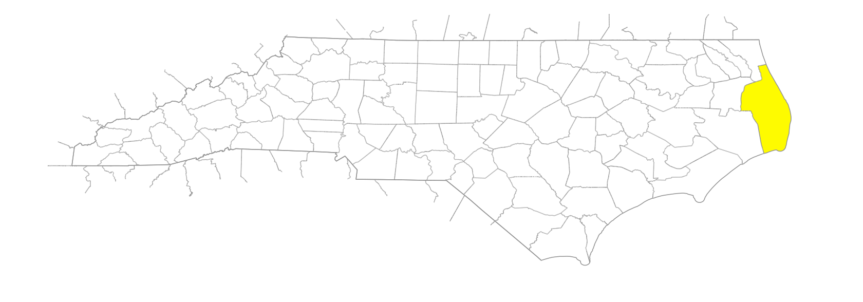
NC Gazetteer

Dare County

… was formed in 1870 from Currituck, Tyrrell, and Hyde Counties. Located in the NE section of the state, it is bounded by the Atlantic Ocean; Pamlico, Croatan, and Albemarle Sounds; and Hyde and Tyrrell Counties. It was named for Virginia Dare, born August 18, 1587, on Roanoke Island in the county; she was the first child of English parents to be born in America. Area: 1,246 sq. mi. (388, land; 858, water). County seat: Manteo, with an elevation of 12 ft. Townships are Atlantic, Croatan, East Lake, Hatteras, Kennekeet, and Nags Head. Produces boats, concrete products, cabinets, scuppernongs, figs, poultry, processed seafood, corn, soybeans, and lumber.

areas

Nausegoc
Paquiac
Rowsypock

bays

Ashby Harbor
Broad Creek
Buzzard Bay
Clarks Bay
Deep Bay
Gull Island Bay
Kitty Hawk Bay
Long Shoal Bay
No Ache Bay
Pains Bay
Parched Corn Bay
Sandy Bay
Sandy Bay
Shallowbag Bay
Stumpy Point Bay

beaches

Avalon Beach
Coquina Beach

businesses or business districts

Whalebone

channels

Old House Channel
Rollinson Channel

Coast Guard stations

Big Kinnakeet Coast Guard Station
Chicamacomico Coast Guard Station
Creeds Hill Coast Guard Station
Kill Devil Hills Coast Guard Station
Little Kinnekeet Coast Guard Station
Nags Head Coast Guard Station
Oregon Inlet Coast Guard Station

communities

Avon
Buffalo City
Buxton
Colington
Duck
East Lake
Frisco
Hatteras
Lake Worth
Manns Harbor
Mashoes
Rodanthe
Salvo
Stumpy Point
Wanchese
Waves

coves

Hatteras Bight

creeks

Askins Creek
Baum Creek
Blossie Creek
Broad Creek
Callaghan Creek
Colington Creek
Jean Guite Creek
Mill Tail Creek
Oyster Creek
Peter Mashoes Creek
Swamp Creek
Tom Mann Creek
Whipping Creek
Wild Boar Creek

elevations

Cape Hatteras
Cape Kenrick

forests

Hatteras Woods
Nags Head Woods

former communities

Skyco

groups of islands

Bird Islands
Colington Island
Croatoan Island
Roanoke Marshes

hills

Paul Gamiels Hill

historical markers

Andrew Cartwright historical marker
Battle Of Roanoke Island historical marker
Billy Mitchell 1879-1936 historical marker
Cape Hatteras Lighthouse historical marker
Civil Air Patrol historical marker
Colington Island historical marker
Confederate Channel Obstructions historical marker
Confederate Forts historical marker
Dasemunkepeuc historical marker
Diamond Shoals historical marker
First English Colonies historical marker
Fort Bartow historical marker
Fort Blanchard historical marker
Fort Forrest historical marker
Fort Huger historical marker
Freedmen's Colony historical marker
Joachim Gans historical marker
Mirlo Rescue historical marker
Naval Battle Of Roanoke Island historical marker
Pea Island Lifesavers historical marker
Port Ferdinando historical marker
R. A. Fessenden historical marker
U.S.S. Monitor historical marker
Wreck Of The U.S.S. Huron historical marker
Wright Brothers historical marker

historical sites

Fort Bartow
Fort Raleigh

inlets

Caffey's Inlet
Chancandepeco Inlet
Hatorask Inlet
Loggerhead Inlet
New Inlet
Oregon Inlet
Roanoke Inlet

islands

Bermuda Island
Big Island
Big Island
Bodie Island
Bunton Island
Cedar Island
Cutoff Island
Duck Island
Durant Island
Etacrewac
Garr Island
Great Island
Green Island
Hatteras Island
Herring Shoal Island
Kings Island
Midgett Island
No Ache Island
Off Island
Pea Island
Roanoke Island

lakes

Back Lake
East Lake
South Lake

peninsulas

Bald Point
Ballast Point
Broad Creek Point
Durant Point
Long Point
Shellbank Point
Stumpy Point

points

Baum Point
Briery Hall Point
Brooks Point
Cape Point
Caroon Point
Cedar Point
Cypress Point
Davids Point
Eagleton Point
Fleetwood Point
Gibbs Point
Greens Point
Haulover Point
Lake Point
Laurel Point
Long Point
Long Shoal Point
Mann Point
Martins Point
Northwest Point
Parched Corn Point
Redstone Point
Reeds Point
Sand Point
Sandy Point
South Point
Theoff Point
Weir Point

points of interest

Wright Brothers National Memorial

populated places

Chicamacomico
Tri-Villages

prongs

Northeast Prong [South Lake]

regions

Coastal Plain
Coastal Plain Dialect Region
Outer Banks
Outer Banks Dialect Region

reserves

Cape Hatteras National Seashore
Pea Island National Waterfowl Refuge

ridges

Jockey's Ridge

rivers

Alligator River
Long Shoal River

sandhills

Engagement Hill
Kenricks Mounts
Kill Devil Hill
Run Hill
Seven Sisters

schools

Cape Hatteras Secondary School
Dare Learning Academy
First Flight High School
Manteo High School

seawater areas

Canadian Hole
Oliver Reef

shoals

Blockade Shoal
Clam Shoal
Colington Island Shoal
Diamond Shoals
Egg Shoal
Gull Shoal
Log Shoal
Long Shoal
Shark Shoal
Wimble Shoals

shores

Chicamacomico Banks
Currituck Banks
Kinnakeet Banks

sounds

Albemarle Sound
Croatan Sound
Roanoke Sound

swamps

Great Alegator Dismal Swamp

towns

Carteret
Kill Devil Hills
Kitty Hawk
Manteo
Nags Head
Southern Shores

townships

Atlantic Township
Croatan Township
East Lake Township
Hatteras Township
Kinnekeet Township
Nags Head Township

transportation-related places

S Curves

villages

Roanoac

waterways

Barney Slue
Davis Slough
Port Lane
Trinity Harbor
Walter Slough